Essen
DU-E
Essen comes in sixth place among major German cities and is located in the center of the Ruhr Area, one of the largest urban areas in Europe, comprising 11 independent cities and 4 districts with approx. 600.000 inhabitants. 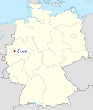 In the year 2002, Essen celebrated the 1150th anniversary of the convent and of the city of Essen. The city limits of Essen itself are 87 km (54 mi) long and border 10 cities, 5 of them independent and 5 kreisangehörig (i.e., belonging to a district), with a total population of approximately 1.4 million.
The city extends over 21 km (13 mi) from north to south and 17 km (11 mi) from west to east, mainly north of the Ruhr River, which forms the Lake Baldeney reservoir in the boroughs of Fischlaken, Kupferdreh, Heisingen and Werden. The lake, a popular recreational area, dates from 1931-1933, when some thousands of unemployed coal miners dredged it with primitive tools for the Reichsarbeitsdienst. Generally, large areas south of the Ruhr River (including the suburbs of Schuir and Kettwig) are quite green and are often quoted as examples of rural structures in the otherwise relatively densely populated central Ruhr Area.
The lowest point can be found in the northern borough of Karnap at 26.5 m (86.9 ft), the highest point in the borough of Heidhausen (202.5 m/664 ft). The average elevation is 116 m (381 ft).
In the year 2002, Essen celebrated the 1150th anniversary of the convent and of the city of Essen. The city limits of Essen itself are 87 km (54 mi) long and border 10 cities, 5 of them independent and 5 kreisangehörig (i.e., belonging to a district), with a total population of approximately 1.4 million.The city extends over 21 km (13 mi) from north to south and 17 km (11 mi) from west to east, mainly north of the Ruhr River, which forms the Lake Baldeney reservoir in the boroughs of Fischlaken, Kupferdreh, Heisingen and Werden. The lake, a popular recreational area, dates from 1931-1933, when some thousands of unemployed coal miners dredged it with primitive tools for the Reichsarbeitsdienst. Generally, large areas south of the Ruhr River (including the suburbs of Schuir and Kettwig) are quite green and are often quoted as examples of rural structures in the otherwise relatively densely populated central Ruhr Area.
The lowest point can be found in the northern borough of Karnap at 26.5 m (86.9 ft), the highest point in the borough of Heidhausen (202.5 m/664 ft). The average elevation is 116 m (381 ft).
City districts
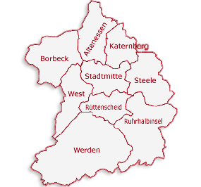
The city of Essen is subdivided into 50 districts which in turn are grouped into nine suburban districts (called Stadtbezirke) often named after the most important boroughs. Each Stadtbezirk is assigned a Roman numeral and has a local body of nineteen members with limited authority. Most of the boroughs were originally independent municipalities but were gradually annexed from 1901 to 1975. This long-lasting process of annexation has led to a strong identification of the population with "their" boroughs or districts and to a rare peculiarity: The borough of Kettwig, located south of the Ruhr River, and which was not annex until 1975, has its own area code. Additionally (allegedly due to relatively high church tax incomes), the Archbishop of Cologne managed to keep Kettwig directly subject to the Archdiocese of Cologne, whereas all other boroughs of Essen and some neighboring cities constitute the Diocese of Essen.
Essen Districts
Essen Weather
General information on Duisburg/Essen
General information on Essen
Prayer Timings in Essen
Getting Here, Around and Away
We show you how to get to Essen by plane, train, or car and to find the right way around the city using the numerous means of transportation.
By Car
Essen is easily accessible from all directions with five motorways creating a dense network of connections throughout the entire city area. The road network of Essen consists of over 3,200 streets, which in total have a length of roughly 1,600 km (994 mi).
Three motorways touch Essen territory, most importantly the Ruhrschnellweg (Ruhr fast way, A 40), which runs directly through the city, dividing it roughly in half. In a west-eastern direction, the A 40 connects the Dutch city of Venlo with Dortmund, running through the whole Ruhr Area. It is one of the arterial roads of the Ruhr Area (> 140,000 vehicles/day) and suffers from heavy congestion during rush hours, which is why many people in the area nicknamed it Ruhrschleichweg (Ruhr crawling way). A tunnel was built in the 1970s, when the then-Bundesstraße was upgraded to motorway standards, so that the A 40 is hidden from public view in the inner-city district near the main station.
In the north, the A 42 briefly touches Essen territory, serving as an interconnection between the neighboring cities of Oberhausen and Gelsenkirchen and destinations beyond.
A segment of the A 52 connects Essen with the more southern region around Düsseldorf. On Essen territory, the A 52 runs from the southern boroughs near Mülheim an der Ruhr past the fairground and then merges with the Ruhrschnellweg at the Autobahndreieck Essen-Ost junction east of the city center.
With the A 40/A 52 in the southern parts of the city and the A 42 in the north, there is a gap in the motorway system often leading to congestion on streets leading from the central to the northern boroughs. An extension of the A 52 to connect the Essen-Ost junction with the A 42 to close this gap is considered urgent[12]; it has been planned for years but not yet been realized - most importantly due to the high-density areas this extension would lead through, resulting in high costs and concerns with the citizens.
By Train & Public transport
If you want to travel to Essen by train, Die Bahn with its travel service will assist you. As with most communes in the Ruhr Area, local transport is carried out by a local, publicly-owned company for transport within the city, the DB Regio subsidiary of Deutsche Bahn for regional transport and Deutsche Bahn itself for long-distance journeys. The local carrier, Essener Verkehrs-AG (EVAG), is a member of the Verkehrsverbund Rhein-Ruhr (VRR) association of public transport companies in the Ruhr Area, which provides a uniform fare structure in the whole region. Within the VRR region, tickets are valid on lines of all members as well as DB's railway lines (except the high-speed InterCity and Intercity-Express networks) and can be bought at ticket machines and service centers of EVAG, all other members of VRR, and DB.
Customer Service Centres
Customer service centres can be found at the following locations:
Customer service centre Hauptbahnhof [central railway station]
in the pedestrian walkway:
Open Mon - Fri, 7.30 - 20 h, Sat 8 - 14 h
Phone 0201/826 -1234
Customer service centre Berliner Platz (also lost property office):
Open Mon - Fri 8 - 19 h, Sat 8 - 14 h
Phone 0201/826 -1234
Customer service centre Steele Verkehrsplatz:
Open Mon - Fri 8 - 18 h, closed Sat
Phone 0201/826 -1234
Customer service centre Rüttenscheider Stern:
Open Mon - Fri 8 - 18 h, Sat 8 - 14 h
Phone 0201/826- 1234